


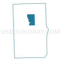
Voting District 0996742000002, Macomb County, Michigan
About
Outline

Summary
| Unique Area Identifier | 597775 |
| Name | Voting District 0996742000002 |
| County | Macomb County |
| State | Michigan |
| Area (square miles) | 20.96 |
| Land Area (square miles) | 20.92 |
| Water Area (square miles) | 0.04 |
| % of Land Area | 99.81 |
| % of Water Area | 0.19 |
| Latitude of the Internal Point | 42.76825330 |
| Longtitude of the Internal Point | -82.88908030 |
Maps

Graphs
Select a template below for downloading or customizing gragh for Voting District 0996742000002, Macomb County, Michigan


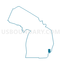
Neighbors
Neighoring Voting District (by Name) Neighboring Voting District on the Map
- Voting District 0990354000002, Macomb County, MI
- Voting District 0994690000001, Macomb County, MI
- Voting District 0994690000002, Macomb County, MI
- Voting District 0995048000024, Macomb County, MI
- Voting District 0996742000001, Macomb County, MI
- Voting District 0991534000019, Macomb County, MI
- Voting District 099684000002, Macomb County, MI
Top 10 Neighboring County Subdivision (by Population) Neighboring County Subdivision on the Map
- Macomb township, Macomb County, MI (79,580)
- Chesterfield township, Macomb County, MI (43,381)
- Lenox township, Macomb County, MI (10,470)
- Armada township, Macomb County, MI (5,379)
- Ray township, Macomb County, MI (3,739)
- Richmond township, Macomb County, MI (3,665)
Top 10 Neighboring Unified School District (by Population) Neighboring Unified School District on the Map
- Romeo Community Schools, MI (34,011)
- New Haven Community Schools, MI (14,646)
- Richmond Community Schools, MI (12,514)
- Armada Area Schools, MI (9,129)
Top 10 Neighboring State Legislative District Lower Chamber (by Population) Neighboring State Legislative District Lower Chamber on the Map
Top 10 Neighboring State Legislative District Upper Chamber (by Population) Neighboring State Legislative District Upper Chamber on the Map
Top 10 Neighboring 111th Congressional District (by Population) Neighboring 111th Congressional District on the Map
Top 10 Neighboring Census Tract (by Population) Neighboring Census Tract on the Map
- Census Tract 2120, Macomb County, MI (5,379)
- Census Tract 2100, Macomb County, MI (4,488)
- Census Tract 2160, Macomb County, MI (3,739)
- Census Tract 2170, Macomb County, MI (2,668)
- Census Tract 2235, Macomb County, MI (1,271)
- Census Tract 2215, Macomb County, MI (1,067)
Top 10 Neighboring 5-Digit ZIP Code Tabulation Area (by Population) Neighboring 5-Digit ZIP Code Tabulation Area on the Map
- 48042, MI (27,291)
- 48051, MI (17,319)
- 48062, MI (9,373)
- 48048, MI (7,548)
- 48005, MI (5,379)
- 48096, MI (3,739)
- 48050, MI (1,653)